ITM - Carte - Mexique
| Destination | Amérique du nord |
|---|---|
| Pays / Région | Mexique |
| Edition, collection | I.T.M (International Travel maps) |
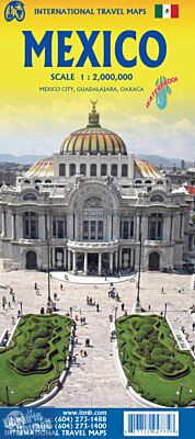
Une carte recto-verso et imperméable du Mexique au 1/2.000.000ème (1cm = 20km) avec un focus sur les villes de Mexico (au 1/12.500ème, 1 cm = 125m), de Guadalajara (1/10.000ème, 1 cm = 100m) et Oaxaca (1/16.000ème, 1 cm = 160m).
Détails de l'article
Voici comment l'éditeur présente ce titre sur son site :
Mexico is a fascinating country, and as travel re-opens, is proving to be very popular. This most recent edition was recently printed, and is now the current edition. Double sided detailed travel map, with comprehensive place name index. Distinguishes roads ranging from expressways (free/toll) to rural roads. Legend includes railways, tracks, trails, international airports, domestic airports, bridges, border crossing points, points of interest, archaeological sites, beaches, active volcanos, filling stations, national parks, deserts, places of touristic interest. Printed on durable, water-resistant plastic paper, suitable for travelling in areas with extreme humidity. This is another chestnut in the ITMB line, and sells well. The cover picture is new, as is the ISBN. Mexico is a very large and diverse country, and very popular with Americans. Again, there is little one can say that is news about such a tried-and-true map, except to say that it is extremely popular.
Map size: 27*39"
(Source : ITMB)