- Accueil
- Cartographie
- Cartes routières
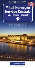
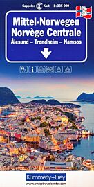
- Kummerly Frey (Cappelen Kart) - Carte de Norvège centrale n°4 (Lofoten, Narvik, Broennoeysund)
Kummerly Frey (Cappelen Kart) - Carte de Norvège centrale n°4 (Lofoten, Narvik, Broennoeysund)
| Destination | Europe |
|---|---|
| Pays / Région | Norvège |
| Edition, collection | Kummerly-Frey |
Une carte routière détaillée au 1/400.000ème (1cm = 4km) et bien lisible !
Détails de l'article
Voici comment l'éditeur présente ce titre sur son site :
The maps have bold, effective relief shading with numerous spot heights and names of geographical features such as mountain ranges, glaciers, valleys, waterfalls, etc, to indicate the country’s mountainous terrain. Colours show the vast forested areas and national parks are highlighted. Road network includes minor local roads, cart tracks, tolls, winter closures, steep gradients, etc. Railways, ferry connections and, in remote areas, hiking trails with walking times are also shown and local administrative boundaries are marked.
The maps are particularly good at highlighting accommodation facilities, with an extensive range of symbols showing hotels, motels, campsites, youth hostels, etc., indicating different standards and categories. Other symbols show places of interest, viewpoints, bird colonies, etc. Latitude and longitude lines are drawn at 15’ and 30’ respectively. There is no index of place names. Map legend includes English.
(Source : Kummerly+Frey)


