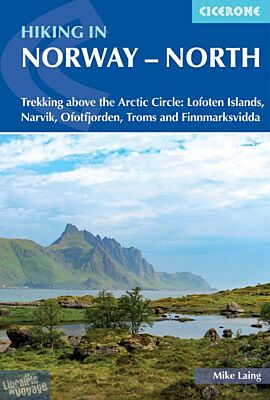
Cicerone - Guide de randonnées (en anglais) - Hiking in Norway - North (Trekking above the Arctic Circle - Lofoten Islands, Narvik, Ofotfjorden, Troms and Finnmarksvidda)
| Destination | Europe |
|---|---|
| Pays / Région | Norvège |
| Région / Ville | Lofoten |
| Auteur | Mike Laing |
| Date de publication | 22 nov. 2024 |
| Edition, collection | Cicerone Editions |
Ce guide, en anglais, décrit (et le fait bien) des randonnées sur plusieurs jours (de 4 à 10 jours)
Détails de l'article
Voici comment l'éditeur présente ce titre sur son site :
Guidebook to trekking in Norway above the Arctic Circle, including the Lofoten Islands, the mountains around Narvik and Ofotfjord, Tromso and the Troms region, and Finnmarksvidda in the far north east. Treks range from 48 to 165km in length and take between four and ten days to walk. Includes 1:100,000 maps, itineraries and accommodation guide.
Seasons
Due to the northern latitude, trails are viable for a relatively short season between early July (mid June for Lofoten Islands) and mid September.
Centres
Narvik, Abisko (Sweden), Sørvågen, Leknes, Karasjok, Alta
Difficulty
All the trails are non-technical in nature with no specialist skills required, but experience of navigation and multi-day hiking are essential. Residual, easy angled snow at elevation, especially early in the season, may require confidence.
Must See
Fjords and peaks of the magnificent Lofoten Islands; remote wilderness of Inner Troms; rolling tundra of Finnmarksvidda; Arctic flora and fauna; 24-hour daylight
A guidebook to trekking in Norway north of the Arctic Circle, including the Lofoten Long Crossing in the region's south-west and the Finnmarksvidda in the far north-east. From 48-165km (30-103 miles) in length and taking between 4 and 10 days to walk, the trails cover mountain terrain and remote tundra and may cross residual snow at elevation, so are suitable for experienced hikers and backpackers.
Each of the five multi-day treks is described in detail, with accommodation, facilities and transport options highlighted, and alternative itineraries listed where relevant. Some of the trails criss-cross over the border into neighbouring Sweden and Finland.
Includes 1:100,000 mapping of each stage, with 1:500,000 trek overview maps also provided
Handy route summary tables, stage facilities planner and accommodation listings help you plan your itinerary
Details of transport and refreshments included for each trek
GPX files available to download
Sized to easily fit in a jacket pocket
(Source : Cicerone)