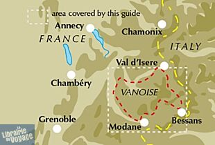
Cicerone - Guide de randonnées (en anglais) - Trekking in the Vanoise - Tour of the Vanoise and the Tour des Glaciers de la Vanoise

Plus d’information
Destination France
Pays / Région Auvergne-Rhône-Alpes
Région / Ville Savoie
Date de publication 24 nov. 2021
Edition, collection Cicerone Editions
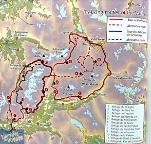
Le topoguide en anglais du tour de la Vanoise. 150 km décrits en 11 jours. Le tour des glaciers de la Vanoise est également présent.
22,90 €
En stock
Expédition demain matin

Détails de l'article

Voici comment l'éditeur présente ce guide sur son site :

A guide to the Tour of the Vanoise, a 150km hut-to-hut trek in the French mountains between Mont Blanc and the Ecrins, described in 11 day stages from Modane. Also included are the Tours des Glaciers de la Vanoise plus suggestions for other multi-day treks in the national park.
Seasons
The summer trekking season - mid-June to the end of September
Centres
Modane, Termignon, Bonneval-sur-Arc, Val d'Isère, Tignes, Pralognan-la-Vanoise
Difficulty
Mostly easy trekking at fairly high altitude. A few optional route variants cross high and remote cols, whilst a very small number of stages have short sections aided by steps or cables. A great - often overlooked - place to start a trekking lifestyle.
Must See
The Grande Casse and Grande Motte, views north to Mont Blanc and south to the Écrins massif, lakes at Plan du Lac and Lozières, the Dent Parrachée, the beautiful Leisse and Rocheure valleys, the wild landscapes of the high passes of the eastern and western Vanoise

This guide describes the eleven-day 163km Tour of the Vanoise and the five-day 72km Tour des Glaciers de la Vanoise, two fantastic hut-to-hut treks through the pristine Alpine landscapes of France's Vanoise National Park. Three other short treks - the Tour of the Eastern Vanoise, the Tour of the Western Vanoise and a Traverse of the Vanoise via the GR5 and GR55 - are also summarised. The routes tackle several passes in excess of 2500m but there are no glacier crossings, no significant scrambling and no lengthy paths exposed to either stonefall or vertigo-inspiring exposure (though optional variants may involve some slightly more challenging sections), and waymarking is usually clear - making this an ideal route for those new to Alpine trekking.

The guide contains everything you need to plan and walk the routes, with advice on travel to the region, accommodation and recommended kit. Clear route description, mapping and overview statistics are provided for each day stage, there are notes on the region's plants and wildlife and other points of interest, and accommodation listings and a handy glossary can be found in the appendices. Completing the package, the beautiful colour photos will call to your wanderlust.

The Vanoise is less well known than its neighbours Mont Blanc and the Ecrins massif but is equally beautiful. The scenery is quintessentially Alpine, with 3000m peaks decorated with gleaming glaciers and snowfields, valleys glistening with lakes and streams, towering moraine walls, impossibly steep rock slabs and, in the early summer, meadows extravagant with a riot of alpine flowers. A well-appointed network of refuges promises a warm welcome at the end of each day's walking. It's a perfect place to experience the pleasures of Alpine trekking and these routes offer the ideal opportunity to explore this magnificent region.

(Présentation de l'éditeur)

Le topoguide en anglais du tour de la Vanoise. 150 km décrits en 11 jours. Le tour des glaciers de la Vanoise (et des variantes) est également présent. 

Cicerone - Guide de randonnées (en anglais) - Trekking in the Vanoise - Tour of the Vanoise and the Tour des Glaciers de la Vanoise
22,90 €

Produits apparentés

I.G.N Carte au 1-25.000ème - TOP 25 - 3633 ET - Tignes - Val-d'Isère - Haute Maurienne - Parc National de la Vanoise
Carte topographique au 1/25.000ème (1cm sur la carte équivaut à 250 mètres sur le terrain)
I.G.N Carte au 1-25.000ème - TOP 25 - 3633 ET - Tignes - Val-d'Isère - Haute Maurienne - Parc National de la Vanoise
  • Edition : IGN - Institut géographique national (Série 1/25000ème)
13,40 €
Hachette - Le Guide du Routard - Tarentaise - Vanoise
Avec ce Routard, gros plan sur cette si délicieuse région. Adresses, indications touristiques et suggestions de balades
Hachette - Le Guide du Routard - Tarentaise - Vanoise
  • Edition : Hachette - Guide du Routard
4,90 €
Editions La Fontaine de Siloë - Guide de randonnées - Vanoise - Haute-Tarentaise à petits pas 40 balades entre marmottes et glaciers Compagnie des guides de la Vanoise
Une belle collection pour randonner en famille. Les parcours sont bien décrits et illustrés. Les cartes sont claires. Nous apprécions les petits commentaires culturels des lieux en "petit plus"
Editions La Fontaine de Siloë - Guide de randonnées - Vanoise - Haute-Tarentaise à petits pas 40 balades entre marmottes et glaciers Compagnie des guides de la Vanoise
  • Edition : Fontaine de Siloë éditions
9,90 €
I.G.N. Carte au 1-25.000ème - TOP 25 - 3534OT - les Trois Vallées - Modane - Parc National de la Vanoise
Carte topographique très détaillée au 1/25.000e (1cm = 250m), l'incontournable carte IGN
I.G.N. Carte au 1-25.000ème - TOP 25 - 3534OT - les Trois Vallées - Modane - Parc National de la Vanoise
  • Edition : IGN - Institut géographique national (Série 1/25000ème)
13,40 €
Editions La Fontaine de Siloë - Guide de randonnées - Maurienne et Vanoise à petits pas - 40 balades entre légendes et glaciers
Une belle collection pour randonner en famille. Les parcours sont bien décrits et illustrés. Les cartes sont claires. Nous apprécions les petits commentaires sur la culture des lieux en "petit plus"
Editions La Fontaine de Siloë - Guide de randonnées - Maurienne et Vanoise à petits pas - 40 balades entre légendes et glaciers
  • Edition : Fontaine de Siloë éditions
9,90 €

Les accessoires de voyage

Utiles, indispensables ou futiles, la librairie offre une sélection d'accessoires pour vos escapades
Association des chemins du Mont-Saint-Michel - Carnet - Carnet du Miquelot

Un carnet dépliant pour vous accompagner le long de votre parcours, valider les différentes étapes au fur et à mesure de vos avancées et, avec au minimum trois tampons, recevoir le Diplôme du miquelot.


Association des chemins du Mont-Saint-Michel - Carnet - Carnet du Miquelot
5,00 €
Sea to Summit - Sigma set - 2 personnes

Un set comprenant : 

1 x casserole Sigmapot 1,9 L
2 x DeltaLight Insulmug
2 x DeltaLight Bowl
Encombrement : 120 x 165 mm pour 610 g

Sea to Summit - Sigma set - 2 personnes
64,95 €
Sea to summit - XBowl (Bol pliant) - Couleur rouille

Idéal pour les repas en camping et randonnée. Un bol pliant d'une contenance de 650 ml pour 80 g. En silicone léger.

Sea to summit - XBowl (Bol pliant) - Couleur rouille
14,95 €
Sea to summit - XBowl (Bol pliant) - Couleur vert-olive

Idéal pour les repas en camping et randonnée. Un bol pliant d'une contenance de 650 ml pour 80 g. En silicone léger.

Sea to summit - XBowl (Bol pliant) - Couleur vert-olive
14,95 €
Sea to summit - XMug couleur vert olive (Tasse pliante)
12,95 €
Lifestraw - Paille de filtration

La nouvelle fonctionnalité : La paille est vissable sur n’importe quel goulot du commerce type bouteille Evian, Badoit ou autre, pour obtenir une eau claire et purifiée (Source : Lifestraw/Nic Impex) 

Lifestraw - Paille de filtration
29,95 €
Sass & Belle - Bento Box - Panier-repas en bambou désign Monde
Une Bento Box, aspect vintage, avec sur le couvercle un imprimé monde. Longueur : 19 cm ; Largeur 13 cm ; Hauteur 6.5 cm. Un panier-repas accompagné d'un élastique (costaud) pour maintenir la boîte bien fermée.
Sass & Belle - Bento Box - Panier-repas en bambou design Monde
14,90 €
Sea to summit - Porte-accessoires étanche - Taille L
Une housse étanche de 15X21.50cm
Sea to summit - Porte-accessoires étanche - Taille L
21,95 €
Georelief - Carte Postale en relief - L'Islande
Une carte postale originale en relief. De quoi donner de la profondeur à votre courrier ! Dimensions : 14,8 x 10,5 cm.
Georelief - Carte Postale en relief - L'Islande
15,90 €
Universe Publishing - Carnet de voyage (en anglais) - The Bucket List Journal, Write your own adventure
Un carnet de voyage (en anglais) à remplir (page en fonction du voyage (lieu, date, personnes rencontrées,...), pages lignées) accompagné de quelques photos et des propositions de lieux à visiter (Top 20 Musées, Top 20 des lieux où nager, Top 20 des lieux à visiter avec moins de 55 dollars par jour, etc).
Universe Publishing - Carnet de voyage (en anglais) - The bucket list journal, write your own adventure
9,90 €