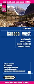
ITM - Carte - Alberta

| Destination | Amérique du nord |
|---|---|
| Pays / Région | Canada |
| Région / Ville | Ouest canadien |
| Edition, collection | I.T.M (International Travel maps) |
Une carte de la province de l'Alberta, dans l'ouest canadien, au 1/940.000ème (1 cm = 9.4 km)
Détails de l'article
Voici comment l'éditeur présente ce titre sur son site :
The Canadian province of Alberta is a perennial favourite map title, and we are very pleased to see the updated 4th edition being released. Containing both Banff and Jasper national parks and the fabulous dinosaur museum as Drumheller, Alberta is a tourism magnet. Calgary is a major point of entry into Canada for those wishing to explore the Rocky Mountains, and camper rentals (with drop-offs in Vancouver) are very common. This double-sided map includes insets of Calgary, Edmonton (the provincial capital), Banff, Jasper (recently damaged by a wildfire), and Lake Louise.
Legend Includes:
Roads by classification, Rivers and Lakes, National Park, Airports, Points of Interests, Highways, Main Roads, Zoos, Fishing, and much more...
(Source : ITM)