- Accueil
- Cartographie
- Cartes routières
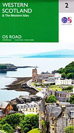
- Nicolson maps - Carte - Road 2 - West Scotland & the Western Isles
Nicolson maps - Carte - Road 2 - West Scotland & the Western Isles
| Destination | Europe |
|---|---|
| Pays / Région | Ecosse |
| Région / Ville | Highlands et îles |
| Edition, collection | Nicolson Map |
Une belle carte qui reprend le contenu des cartes régionales d'Ordnance Survey. Au 1/250.000ème (1cm = 2.50km)
13,90 €
En stock
Détails de l'article
Voici comment l'éditeur présente ce titre sur son site :
Based on the Ordnance Survey 1/250000 Road mapping.
Road Map 2 covers West Scotland & the Western Isles. Please scroll through the images to see the area of coverage (in white). This sheet covers from Dumbarton in the south west, due north to Loch Eribol (east of Durness) all the way west to Lewis, Harris, the Uists, Benbecula & Barra. It also includes an inset of Islay & Jura.
Features:
• Clear road mapping & ferry routes
• Index to place names (which the Ordnance Survey version doesn't have)
• National & forest parks
• Contours and peak heights
(Source : Nicolson maps)
Poids
140 g
Nicolson maps - Carte - Road 2 - West Scotland & the Western Isles
13,90 €
Les accessoires de voyage
Utiles, indispensables ou futiles, la librairie offre une sélection d'accessoires pour vos escapades


